
ABOUT
We Solve Expensive Problems for Complex Projects
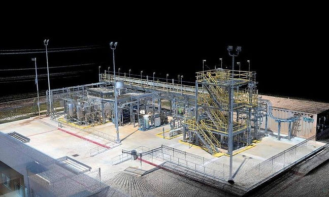
Yes, we Scan


Our Story
Founded in Edmonton, Alberta, Digi 3D Scan Inc. specializes in precision as-built documentation for architecture, construction, and industrial environments.
With offices in Edmonton and affiliates in Toronto, we provide high-accuracy LiDAR scanning and digital documentation services for complex projects across Canada.
Dorian Nicoara, founder of Digi 3D Scan Inc., is a Certified Engineering Technologist (C.E.T.), Project Management Professional (P.M.P.), and Certified Professional Inspector (C.P.I.) with over 30 years of construction industry experience.
What sets Digi 3D Scan Inc. apart is not only our advanced, high-end 3D laser scanning technology capable of handling complex projects, but also our deep understanding of the construction industry. With over 30 years of hands-on experience, we understand the real-world requirements behind the drawings, helping deliver documentation that is both precise and practical

Industries we specialize in
Architecture
Construction
Oil & Gas
What We Deliver

AS-BUILT FLOOR PLANS
01.
Accurate floor plans created from LiDAR scan data, showing existing walls, doors, windows, major openings, ceiling heights, and key building features. Ideal for renovations, permitting, and design planning.

REFLECTED CEILING PLANS
02.
Ceiling documentation showing visible ceiling features such as bulkheads, lights, diffusers, ceiling grids, exposed ducts, and other overhead elements. Useful when ceiling coordination is required.

03.
CAD DRAWINGS
CAD drawing packages prepared for new builds, major renovations, and permit applications. Deliverables can include floor plans, elevations, sections, construction details, and related documentation required for a complete building permit submission.


REVIT / BIM DELIVERABLES
04.
POINT CLOUD DATA
05.
Scan data and documentation prepared to support BIM and Revit workflows. Depending on project requirements, deliverables can support modelling, coordination, and existing condition documentation.
High-density 3D point cloud data captures the existing space with measurable accuracy. Project teams can review site conditions, verify dimensions, and reduce repeat site visits.

06.
VIRTUAL SITE ACCESS
Interactive digital access allows clients and project teams to review existing conditions remotely. This improves communication, reduces site visits, and supports better project decisions.
Project Workflow
Project Consultation
Scope and Proposal
On-Site LiDAR scan
As-Built Documentation
Digital Project Delivery
Tell us about your project requirements, location, and deliverables needed.
We review the scope and provide a clear proposal tailored to your project.
Our team performs a high-accuracy 3D laser scan of the existing conditions.
Point cloud data is processed into accurate CAD, Revit, or as-built deliverables.
Receive your drawings, models, and point cloud files ready for your project team.
We know you're busy.
Here's the tech in 30 seconds. No need to read, just watch.
